
Interactive Subtidal Habitat Maps User Guide
To make the GIS data accessible to a wider audience of varying technical abilities, the Subtidal Goals Project worked with consultants at Stillwater Sciences to develop a Google Maps-based interface. The user can interact with the information and take advantage of the map-server capabilities of Google Maps, namely the ability to turn different layers on and off, zoom in and out of an area of interest, move the map around, or change the base map between satellite imagery, topographic, or traditional map. The interactive maps greatly supplement the hardcopy maps found in the report, which are limited in size and scale.
Suggestions for Use:
- Please note that there is a large amount of data in these maps, and therefore it takes up to 30 seconds to download some map galleries.
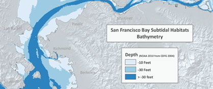
- The data available is formatted by habitat type in the map galleries. The maps that you can view include the particular habitat distributions, stressor layers, and recommended restoration sites that were identified for the Subtidal Goals recommendations.
- Use the zoom tool to see the full breadth of information in the data.
- Users can turn specific habitat type and stressor layers on and off, but can’t combine map galleries at this time.
- If you have knowledge of existing or new data sets that should be included, please contact Marilyn Latta.
More information about the maps.